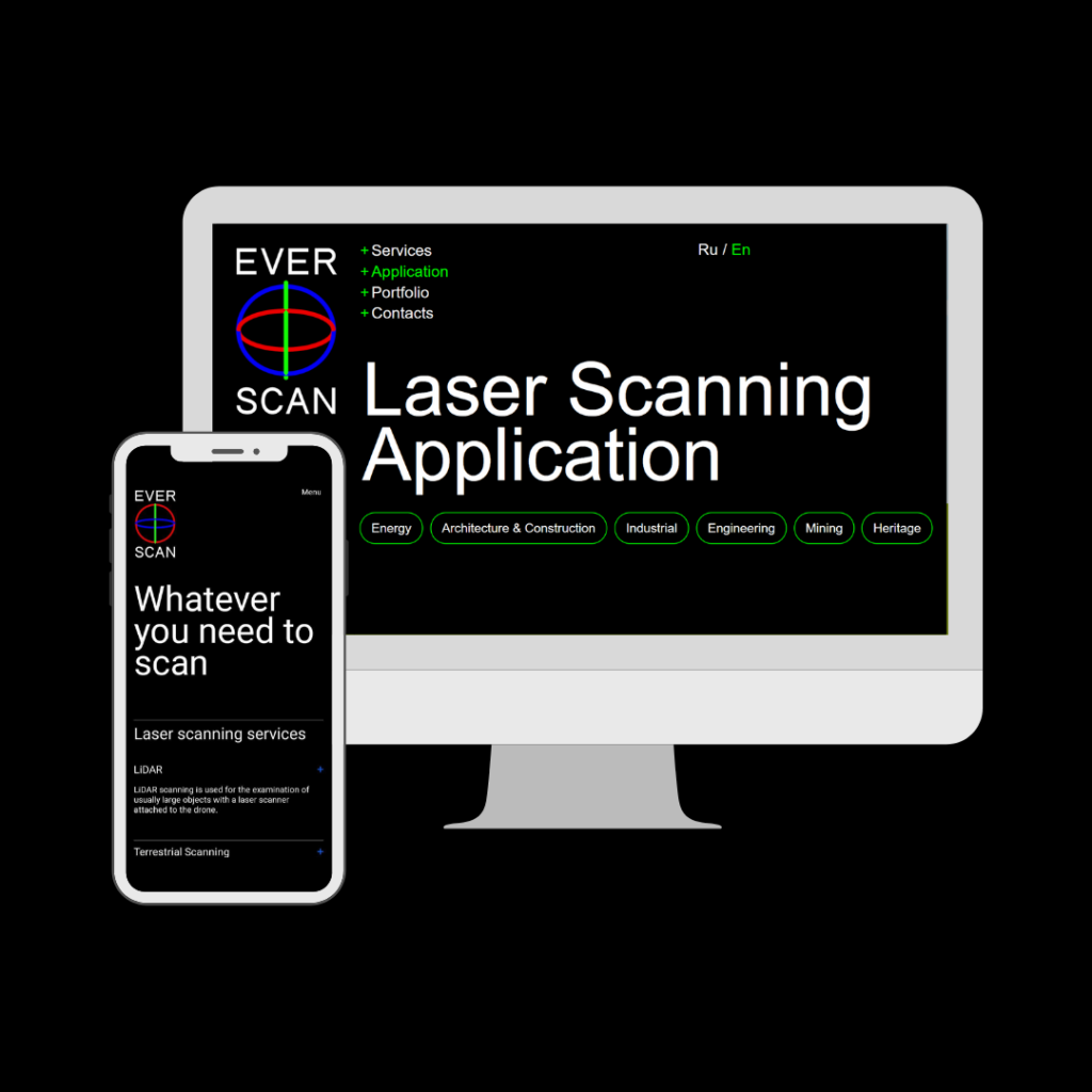
Whatever you need to scan – Everscan.
Everscan was founded by Yaroslav Pokotilo, originating from a maternal Ukrainian company Lemon Construction. The parent structure’s profile is mainly in office design, but the possibilities they saw were so much broader. Using advanced equipment, Everscan inspects and measures everything with millimeter accuracy, starting from tiny artifacts and ending with full-blown cities.
Everscan team is inspired by laser scanning technology and aims towards creating accurate models of cities. Yet it’s not the scanners that are the company’s greatest value, it’s the resulting data that solves the problems of the clients.
The company implemented several projects with Ukrainian giants such as:
- Dymerskaya solar power plant – preventive inspection to detect malfunctions on the panels;
- PMGU MK «Azovstal» & OK-306 SevGOK – perform engineering and geodesic works, laser scanning for subsequent design and modernization;
- Cargill – the restoration of the executive documentation for subsequent modeling and modernization; and many others.
Everscan uses LiDAR technology, which is a remote sensing technology that has a laser pulse collecting measurements that represent a digital copy of the scanned object. Further, the resulting point cloud data can be easily used to create 3D models, and maps of the surroundings. Wherein, the data completeness and accuracy are unbeatable.
This data is perfectly compatible in many applications:
- Energy sector
- Architecture & Construction
- Industrial section
- Engineering (automotive)
- Mining industry
- Heritage
Unexpected to see heritage here, right? There is an easy explanation.
What is the Challenge?
«Historical and Cultural Reserve «Bilsk» is a unique archaeological site of the cultural heritage of Ukraine. The monument is recognized by scientists as the largest fortified settlement in Europe of the Early Iron Age. Nevertheless, the development of archeological science is now absolutely impossible without the use of modern technologies.
Some archaeologists call LiDAR almost magical or extraterrestrial technology, as with its help it is possible to detect archaeological objects, almost invisible to the naked eye, especially those under vegetation.
“Any formation on earth makes the soil heterogeneous, leaving these so-called “footprints”. Even with time, these objects can be seen with the help of LiDAR, which is a chance to preserve history.” says Yaroslav.
In the image below, you can see the “footprint” of the church that existed on this land, all found under a deep layer of vegetation.
What is the Solution?
At the end of 2020, the staff of the Bilsk Reserve initiated a LiDAR survey and the creation of a Digital Terrain Model of the complex in the form of point cloud data. The result of the survey was to help conduct further research on the possibility of deciphering the smallest anomalies that could be classified as for the condition determination.
Everscan used LiDAR equipment that acquired data with accuracy to 2,5 cm which is in accordance with the cartographic scale of the survey 1:500. This accuracy is confirmed via control ground measurements by Everscan’s specialists during the survey.
Compared to any other classical method, a characteristic feature of LiDAR scanning is the high density of measurements per 1 m², and greater accuracy of the obtained results. The photogrammetry method, despite its lower cost, is not competitive when it comes to forested areas or areas with even minimal vegetation.
Special thanks to the Everscan team for comprehensive support and assistance!
The project “Boosting local traditional industries with IT capacities” is implementing by TechUkraine in partnership with APPAU – Association of Industrial Automation of Ukraine, International Association Culture&Creativity Association with the financial support of the German government through GIZ that aims to increase the competitiveness of traditional industries in strong collaboration with Ukrainian IT companies.